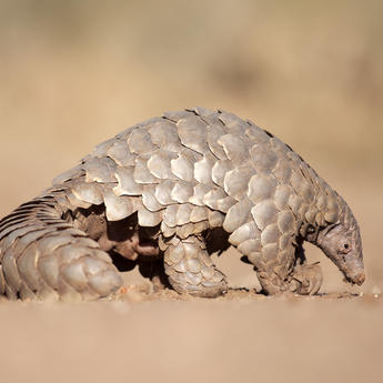
Saving the giant pangolins of Nyakweri Forest
Airbus Foundation and Connected Conservation Foundation partnership boosts conservation efforts with data-driven insights

In early April 2025, Romulus and Remus were in the headlines. Not the legendary founders of ancient Rome, but two fluffy, white dire wolf puppies “de-extincted” by bioengineering firm Colossal Biosciences Inc. some 10,000 years after the species died out.
While the arrival of Romulus and Remus has brought gene-editing technologies as a conservation method into the limelight, it’s important to act to prevent further biodiversity loss now, rather than relying on bioengineering to bring back an endangered species at some point in the future, after they have become extinct. There is already advanced technology being put to work today to restore damaged ecosystems, to improve the ways in which humans and wildlife can coexist, and to protect vulnerable species. Satellites and deep-learning are central to these efforts.
To understand the depth of research being undertaken to boost conservation, we need to travel away from the dire wolves’ 2,000-acre purpose-built ecological preserve in the United States and look to the forests of West and central Africa and, as we shall see, even further east to the Nyakweri Forest.
This is where we find the last giant pangolins in Kenya.
The most trafficked animal in the world
The chances of seeing a giant pangolin in the wild are extremely slim. Pangolins are nocturnal and solitary creatures, and an endangered species. Of the eight different species of pangolins on the International Union for Conservation of Nature (IUCN) Red List, three are listed as critically endangered, three – including the giant pangolin – are endangered, and two are considered vulnerable.
Due to their declining numbers, pangolins are afforded the highest level of protection by the Convention on International Trade in Endangered Species of Wild Fauna and Flora’s (CITES) Appendix I which governs international trade. This is the same level as tigers, red pandas and snow leopards. But despite this, illegal wildlife trade persists and the pangolin remains the world’s most trafficked wild mammal, with an estimated one million pangolins being poached in the last decade. There is high demand for the pangolin’s distinctive scales, which are used in traditional medicine, making pangolin trafficking a potentially lucrative crime.
It was thought until relatively recently that giant pangolins were only found as far east in Africa as Uganda, however, in 2018, the Pangolin Project made a groundbreaking discovery: there were giant pangolins in the Nyakweri Forest, in Kenya, some 500 km further east. While this was positive news, the Nyakweri Forest is also considered high risk, losing more than half its forest cover in the last decade primarily as a result of converting the forest to farmland. The irreversible damage to this ecosystem threatens both the forest’s biodiversity and its ability to support its pangolin population.
Benefitting from the Satellite Sandbox
This is where technology – in this case, low-code deep learning, supported by cutting-edge satellite data – can play a vital role. Deep learning is a machine learning approach that uses complex layers of data to train artificial intelligence, while low-code signifies the use of a more user-friendly interface (i.e. a primarily visual interface, supplemented by some coding for specific tasks). Langland Conservation, a UK-registered charity that specialises in using data-driven insights to support conservation efforts, has been using this technique to work on assessments of deforestation in the Nyakweri Forest, using very high-resolution imagery from Airbus Pléiades Neo satellites.
Langland Conservation’s study of the Nyakweri Forest was split into two parts: one focusing on the impact of electric fences on pangolins, and another analysing deforestation trends to map the remaining forest cover, identify drivers of habitat destruction and pinpoint priority areas to target for forest restoration efforts and the creation of wildlife corridors to reconnect pangolin habitats.
The study was supported and made possible by the Connected Conservation Foundation (CCF) and the Airbus Foundation. The findings of these two studies are now available as part of the CCF’s new Ecosystem Insight Hub. The Hub accelerates innovative approaches that integrate high-resolution satellite imagery, AI and in-situ field data, to monitor and protect nature. It shares analysis methods and learnings from all of the projects that have benefitted from the Airbus Foundation and CCF’s Satellites for Biodiversity Award, providing a valuable resource for GIS (geographic information system) practitioners and AI developers to replicate new techniques to protect other species and geographies.
Langland Conservation received access to Airbus very high-resolution satellite data in 2023 as one of four projects in the Masai Mara Satellite Sandbox.
Bespoke data models that improve over time
When is a fence not a fence? When it’s a track. Or a field edge. That might be obvious when you’re standing right on top of it, but to analyse some 1,000 km² of land, satellite data needs to do the heavy lifting before a ground team can go in. By mapping forest cover and analysing the data to pinpoint key drivers of deforestation, and areas for ecosystem connectivity, the team can identify priority areas for habitat restoration and strengthen community-led conservation efforts for the giant pangolin.

Remaining forest cover within the priority conservation area, March 2024 © Langland Conservation
Remaining forest cover within the priority conservation area, March 2024 © Langland Conservation
Very high-resolution satellite data can capture extraordinary detail from space, with the team at Langland Conservation benefitting from Pléiades Neo 30 cm imagery. But the deep learning algorithms that scan satellite data to find the fences needed to be taught how to tell the difference between different types of markers. With a dataset of 65,000 fence examples, the Nyakweri Forest data was rotated and augmented to provide variations of each image that the model could learn from. With a dynamically optimised learning rate – where the model adapts the pace and increments of learning based on feedback it receives as it goes – the model soon improved from 4% to 16% accuracy. With further work, it provided satisfactory mapping of boundaries and ecosystem connectivity across the target area.
The need to refine the deep-learning models underlines an important insight: to get the most out of a complex dataset there is a constant process of adaptation and learning. Although there were challenges in mapping linear features like fences, the model performed well against broad landscape features such as buildings or water sources. As a result, the model was used primarily as a starting point for general fence detection, with on-the-ground verification and targeted engagement in local communities as a second step. Using the maps and analysis, Langland Conservation worked closely with the Pangolin Project and their local field team to engage with communities, target restoration activities and remove and de-electrify fences where they posed a risk to pangolins. The objective is to create safe wildlife corridors for pangolins, while continually adapting to new on-the-ground challenges as they emerge.

Fence and boundary recognition training data using AI and Pléiades Neo satellite imagery
Fence and boundary recognition training data using AI and Pléiades Neo satellite imagery © Langland Conservation
Given the large number of pangolins every year that die as a result of electrocution from electric fences, and the vast area to cover, this combination of big data, human verification and community outreach stands to make a real difference for the pangolins in Nyakweri Forest.
Supercharging conservation with technology, data and AI
Langland Conservation was one of the beneficiaries of the first Satellites for Biodiversity Award in 2023, but these awards aren’t just to benefit pangolins. The 2025 winners include projects to restore a habitat for western chimpanzees in Guinea which are at risk of displacement by the construction of a railway line and to map seagrass loss in Thailand which is impacting the local dugong population. Data reveals that half of the population in 2024 was malnourished as a result of their changing habitat.
Ecosystems are complex and interconnected, and when natural habitats decline the impact can be significant on plants and animals alike. Another project in the 2025 selection explores the remarkable rise in bark beetle infestations on Giant Sequoia trees in California. A sudden spate of deaths of these ancient trees, which can live for several thousand years, could have a far-reaching impact on soil health, water regulation and wildlife habitat in the Sierra Nevada mountains and beyond.
Projects like these demonstrate the powerful way that insights, analytics and community-led endeavour can protect and restore the many diverse ecosystems on our planet – ecosystems which are increasingly under threat as a result of climate change and human activity. This was a core objective of the annual Satellites for Biodiversity Award when it was launched by the Airbus Foundation and CCF in 2021: to supercharge biodiversity and ecosystem conservation efforts by bringing together satellite imagery, artificial intelligence and the power of big data.
Instead of relying on the ability to “de-extinct” endangered species like pangolins, we need to act now to save them. There are dedicated field teams who can make a real difference, they just need access to innovative technology to help them do it.

Airbus Foundation
Related news
Continue Reading

The last stand of the Ethiopian wolf
Web Story
Airbus Foundation
Find out how Airbus satellites and local partnerships are driving conservation
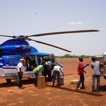
How aviation partnerships are strengthening humanitarian logistics
Web Story
Airbus Foundation
2024: The Airbus Foundation’s year in review
Web Story
Airbus Foundation
Saving the giant pangolins of Nyakweri Forest
Web Story
Airbus Foundation

Airbus Foundation and Solar Impulse Foundation launch call for projects
Web Story
Sustainability


