Satellite imagery is vital when it comes to saving our Planet’s forests and wildlife - says Wendy Carrara, Senior Manager for Digital Services at Airbus Defence and Space.
Wendy, the EU Council recently agreed on new rules to drive down deforestation and forest degradation. What is Airbus doing to help save our planet’s vegetation?
The new EU regulation is the first of its kind to take such a global approach. I’m really looking forward to the final text being voted on by Parliament this autumn. All in all, for the regulation to have a sustainable impact, satellite imagery is going to be essential. And this is where we at Airbus come in: understanding the vegetation’s lifecycle using satellite images is something we have been working on and delivering for more than 20 years. Each crop or tree has its own characteristics that can be analyzed and recognised from space: through free and open data from Airbus-built Copernicus Earth Observation satellites or our own Pléiades Neo satellite constellation that offers very high resolution imagery of up to 30cm. More particularly when it comes to forests, our Starling solution provides industry-wide services to many stakeholders so that those operating in our rainforests can do so sustainably.
And how does that work exactly?
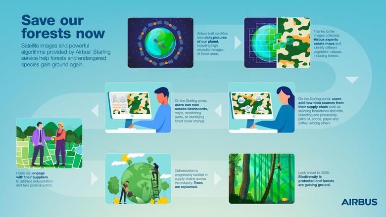
Starling combines more than half a million up-to-date satellite images with powerful machine learning analytics to monitor deforestation. Additional data such as boundary lines and protected areas are also used together with supply chain data provided by our users for various commodities such as palm oil, cocoa, pulp and paper. Thanks to all this data and powerful automated analyses developed by our Airbus experts, Starling sheds light on and helps understand the dynamics of forest cover change and the impact of human activities to better protect vital areas like rainforests. Users can therefore achieve their deforestation commitments when it comes to their supply chain . The use of Starling drives both awareness and local action, enhancing transparency and by doing so helps transform the way resources are produced or harvested. Our customers can then better measure their impact, communicate on their results and overall progress.
See infographics below to learn how Starling works
How much forest has Starling already saved?
It has already saved thousands of hectares of forest - for example in Africa or in South-East Asia. Food and beverage company Nestlé, for instance, has been using Starling since 2019 to track its palm oil supply chain. In 2021, Ferrero monitored 1,225 million hectares of forest, ensuring its palm oil supply chain was 99% deforestation free (for more details, click here). It’s not just palm oil, it’s also other commodities Starling supports, such as cocoa, pulp, paper and more.
What else?
Recently, we signed an agreement with NGO Fairtrade to develop a pilot on deforestation and environmental vulnerability together with smallholder farmers in Ghana and Côte d’Ivoire. Typical actions here will result in further awareness raising around deforestation and forest degradation for further sustainable forest management practices linked to Cocoa (for more information, click here).
That sounds very promising. Where will deforestation stand in a decade from now?
I am optimistic that a lot can be achieved in the coming ten years. We have all the tools to do so and an unprecedented political will to move forward. It’s quite unique and exciting to have this double momentum. Humanity will be able to produce the necessary commodities for agro-food and manage deforestation caused by all sorts of other industrial activities in a sustainable fashion. More importantly, tools such as Starling can further support replanting activities and be a cornerstone for sustainable forest management globally. There are going to be areas where forests are gaining ground and expanding again. As a result, we might be lucky enough to even spot some species of birds or frogs again that we all thought were on the verge of disappearing. I am very much aware that we still have a long way to go, but we have already demonstrated positive results and the use of satellite imagery will make all this possible and at scale.
Download Infographic
Download
Document
Save our forest now - infographic
Document

