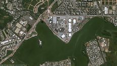
Airbus Defence and Space’s Pléiades constellation of satellites provided detailed monitoring of the construction of one of four sites for the 2016 International sports championship in Brazil.
Located in the south-western part of Rio de Janeiro, the suburb of Barra da Tijuca is to host 16 International sports and nine Paralympic sports on the area of 1.18 million square metres.
Two very-high-resolution radar and optical satellites, Pléiades 1A and Pléiades 1B, tracked excavation and earthworks as well as the construction of infrastructures from July 2012 to May 2016.
On the annotated plans that they immediately produced, it is possible to see the installation of different types of covering and roofing and to distinguish between concrete pillars and steel beams. The pictures from an early stage of construction reveal several material storage and handling sites.
On the image from August 2015, the finishing touches are being made to the stadiums. The traffic and transport development works are apparent and constitute the structural backbone of the site. A main pedestrian route winds its way alongside the stadiums and a tramway line is under construction to the north of the site.
As buildings with metal structures return a strong signal, they appear bright white. Smooth surfaces, such as alleys and the water in the lagoon, are black because they reflect a weaker signal. The progress of construction can be monitored together with the movements of building materials and the appearance of new structures. New objects appear bright green and objects that have disappeared are red, while vegetation, which changes only slowly, is a yellowish-green tone visible on the edges of the lagoon.
The identical twin satellites, which operate in the same orbit phased 180° apart, provide the coverage of Earth’s surface with a repeat cycle of 26 days.
In the case of the Rio International sports competition, engineers have used annotated satellite imagery during the pre-construction phase to prepare infrastructure projects and during construction to keep track of their progress. In another project, Pléiades monitored fields distributed over several US states during the growing season.
But alongside commercial use, the Pléiades constellation also meets defence needs. Defence and Security applications have come to rely on satellite imagery as a crucial source of information, offering knowledge of the territory, discrete surveillance and frequent passes over any point on the globe.
Pléiades is ideally suited for precision mapping of detailed and small targets and photointerpretation. With a daily revisit capability to anywhere in the world, it is able to acquire very high-resolution imagery in less than 24 hours, in response to a crisis or natural disaster.
More Info:
