Give me five . . . satellite snapshots of climate change
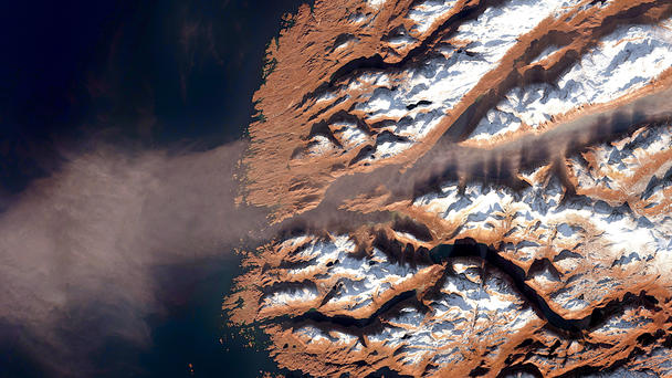
Our climate is changing. Global average temperatures and sea levels are rising, precipitation is changing, becoming more frequent and more severe. A wide range of extreme weather events such as storms, droughts and heat waves are occurring more frequently and are more severe. Dangers to life and property are increasing in frequency and intensity as a result of climate change, writes the World Meteorological Organisation (WMO). The European Environment Agency EEA calls for a better link between knowledge and action, and science and politics and sees the need to generate new knowledge from a wide range of disciplines. Satellites, with their diverse measuring instruments, their high repetition rates, and their literally global overview and long-term programmes, provide the necessary basic data to create new knowledge and initiate new actions.
Five areas of climate change and exemplary image evidence from orbit. Airbus-built satellites in action for environmental protection, sustainability and disaster management.
Atmosphere - Concentrations of the major greenhouse gases, CO2, CH4, and NO2, continued to increase in 2020. 4.2 million people die every year as a result of exposure to poor outdoor air quality.
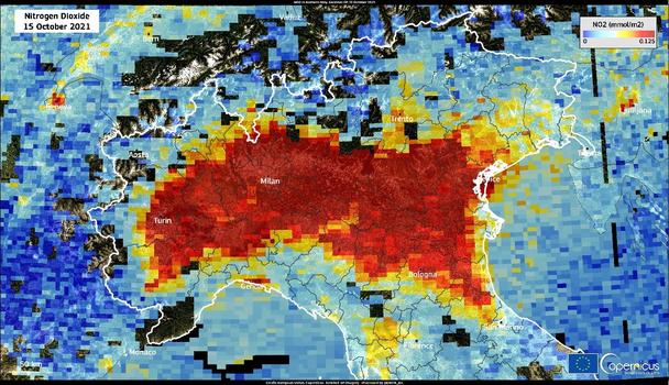
This image is a visualization of the data acquired by the Copernicus Sentinel-5P satellite on 15 October 2021 and shows the concentration of nitrogen dioxide (NO₂) in the Po Valley in northern Italy. The NO₂ levels measured by Sentinel-5P in mid-October are higher than those measured at the beginning of March 2021. This results from the presence of a strong high pressure system that affected atmospheric circulation and caused a widespread deterioration in air quality.
The Copernicus Sentinel-5P mission is the first Copernicus satellite mission dedicated to monitoring the composition of the Earth's atmosphere. Its main objective is to perform measurements of air quality, climate forcing (external factors, such as greenhouse gas emissions or volcanoes, which affect the climate’s energy balance), UV radiation and ozone concentration with high spatio-temporal resolution.
Credit: European Union, Copernicus Sentinel-5P imagery
Cryosphere, Ice and Glaciers - The Antarctic mass loss trend accelerated around 2005, and currently, Antarctica loses approximately 175 to 225 Gt of ice per year. The trend in sea-level rise is accelerating.
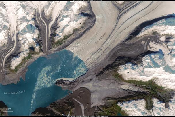
This image, acquired by one of the Copernicus Sentinel-2 satellites on 26 September 2021, showsis showing the Columbia Glacier in Alaska. The glacier is one of the fastest moving in the world and has been closely monitored since the 1980s when a massive glacial retreat was first observed. Since then, the glacier has lost more than 50% of its total thickness and volume, and in 2011 split into two separate glaciers due to accelerated calving and ice loss. The retreat of the glacier contributes to rising sea levels, mostly through iceberg calving. Whilst tidewater effects are a major driver of the ice loss, the rapid retreat of the Columbia Glacier is also attributable to long-term climate-related thinning.
Credit: European Union, Copernicus Sentinel-2 imagery
Ice losses from Antarctica have tripled since 2012, increasing global sea levels by 3 millimeters in that timeframe alone, according to a major new international climate assessment funded by NASA and ESA (European Space Agency).
According to the study (Ice Sheet Mass Balance Inter-comparison Exercise - IMBIE), ice losses from Antarctica are causing sea levels to rise faster today than at any time in the past 25 years. The IMBIE team looked also at the mass balance of the Antarctic ice sheet from
1992 to 2017 and found ice losses from Antarctica raised global sea levels 7.6 millimeters, with a sharp uptick in ice loss in recent years.
The satellite missions providing data for this study are - amongst others - the Airbus-built satellites GRACE, Envisat, CryoSat-2, Sentinel-2 and TerraSAR-X as well as Sentinel-1 carrying an Airbus-C-Bband-radar.
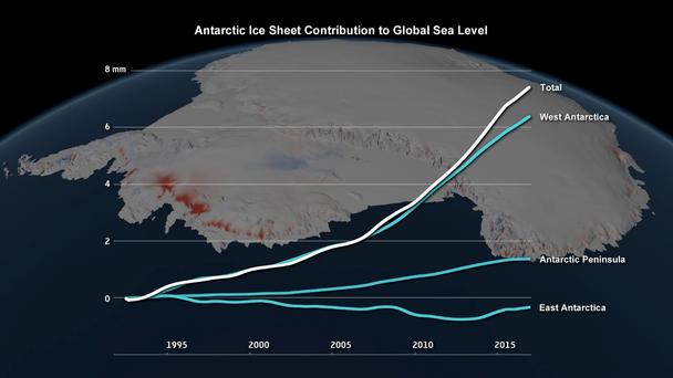
Changes in the Antarctic ice sheet’s contribution to global sea level, 1992 to 2017. Credits: IMBIE/Planetary Visions
Heatwaves and Droughts - 2020 was one of the three warmest years on record. The past six years, including 2020, have been the six warmest years on record. Temperatures reached 38°Cat Verkhoyansk, Russian Federation on 20 June 2020, the highest recorded temperature anywhere north of the Arctic Circle.
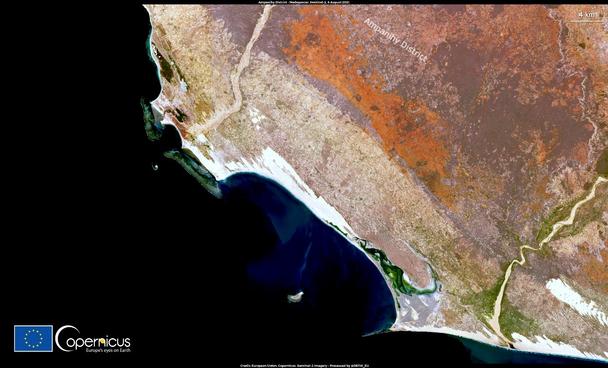
This image acquired by one of the Copernicus Sentinel-2 satellites on 6 August 2021, shows the Ampanihy district in southern Madagascar. According to the United Nation’s World Food Programme, southern Madagascar is going through the highest internationally recognized level of food insecurity as a consequence of the worst drought in 40 years.
This condition, which experts consider to be a manifestation of climate change, caused severe damages to agricultural production during the main harvest period of May-June 2021, with losses of up to 60 percent.
Credit: European Union, Copernicus Sentinel-2 imagery
Floods and Storms - The 2020 North Atlantic hurricane season was exceptionally active. Hurricanes, extreme heatwaves, severe droughts and wildfires led to tens of billions of US dollars in economic losses and many deaths.
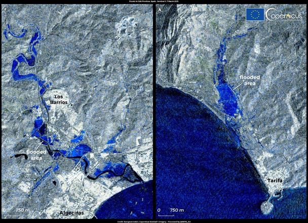
The Province of Cádiz in the south of Spain has been affected by severe weather and heavy rainfall. On 6 and 7 March 2021, a peak volume of 90 litres per square metre in one hour was recorded. Due to the intense rainfall, the Spanish State Meteorological Agency (AEMET) issued a temporary yellow alert in parts of the province.
As the period of severe weather in Cádiz developed, it caused widespread flooding, which prompted the Spanish Directorate-General for Civil Protection and Emergencies to issue an orange alert in the area around the Strait of Gibraltar, the worst affected region. Data supplied by the radar instruments of Copernicus Sentinel-1 satellites allow for the monitoring and mapping of regions affected by flooding by seeing through the cloud cover and providing data that may not be available to optical satellites.
This image, acquired by the Copernicus Sentinel-1 satellite on 7 March 2021 at 06:27 UTC, shows the flooded areas near Tarifa and in Los Barrios.
Credit: European Union, Copernicus Sentinel-1 imagery
Deforestation, Global Forest Biomass - The statistics published by Brazil’s National Institute for Space Research (INPE) show that Brazil’s Amazon region has suffered its worst rate of deforestation in 12 years with 11,088 km² of the rainforest - equivalent to 14 times the size of New York City - lost between August 2019 and July 2020.
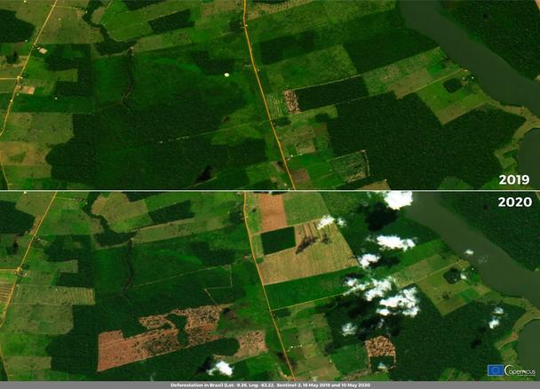
The Amazon rainforest in Brazil is one of the most biodiverse biomes of the world. Although considered vital in slowing global warming, it is threatened by deforestation. This image, acquired by one of the Copernicus Sentinel-2 satellites on 4 October 2020, shows the province di Aripuanã in Mato Grosso, one of the areas in Brazil most devastated by the recent escalation in deforestation.
This picture compares two images acquired by Copernicus Sentinel-2 satellites on 19 May 2019 and 10 May 2020 in the area southeast of Porto Velho, showing the extent of deforestation.
Credit: European Union, Copernicus Sentinel-2 imagery